Spherical models#
We have already mentioned spherical coordinates in Optional parameter: coordinate system. In this section we will focus on converting our current Cartesian model to a spherical model.
To convert, two changes need to be made:
The coordinate system should be set to spherical and a depth method needs to be set.
The coordinates you provide need to be changed from Cartesian to spherical.
To simplify the transition for this tutorial, we will just divide each coordinate by 10000 which will put this into a nice degree range.
 1{
 2  "version":"1.2",
 3  "coordinate system":{"model":"spherical", "depth method":"begin segment"},
 4  "cross section":[[0,0.5],[1,-0.5]],
 5  "features":
 6  [
 7    {
 8       "model":"mantle layer", "name":"upper mantle", "max depth":660e3,
 9       "coordinates":[[-10,0],[-10,10],[30,10],[30,0]],
10       "composition models":[{"model":"uniform", "compositions":[4]}]
BST_19_spherical_models.wb
BST_19_spherical_models.grid
Paraview Spherical state file
 1{
 2  "version":"1.2",
 3  "coordinate system":{"model":"spherical", "depth method":"begin segment"},
 4  "cross section":[[0,0.5],[1,-0.5]],
 5  "features":
 6  [
 7    {
 8       "model":"mantle layer", "name":"upper mantle", "max depth":660e3,
 9       "coordinates":[[-10,0],[-10,10],[30,10],[30,0]],
10       "composition models":[{"model":"uniform", "compositions":[4]}]
11    },
12    {
13       "model":"oceanic plate", "name":"Overriding Plate", "max depth":100e3,
14       "coordinates":[[0,0],[0,10],[15,10],[16,3.5],[15,0]],
15       "temperature models":
16         [
17           {"model":"half space model", "max depth":100e3, "spreading velocity":0.04,
18            "ridge coordinates":[[[4,-0.001],[-1,20]]]}
19         ],
20       "composition models":[{"model":"uniform", "compositions":[0], "max depth":50e3}]
21    },
22    {
23       "model":"continental plate", "name":"Passive margin", "max depth":[[200e3]],
24       "coordinates":[[-10,0],[-10,10],[0,10],[0,0]],
25       "temperature models":
26         [
27           {"model":"linear", "max depth":[[100e3],[200e3,[[-2.5,0],[-7.5,10]]]]}
28         ],
29       "composition models":
30         [
31           {"model":"uniform", "compositions":[3],
32            "max depth":[[100e3],[200e3,[[-2.5,0],[-7.5,10]]]]},
33           {"model":"uniform", "compositions":[1],
34            "min depth":[[100e3],[200e3,[[-2.5,0],[-7.5,10]]]]}
35         ]
36    },
37    {
38      "model":"oceanic plate", "name":"Subducting Oceanic plate", "max depth":300e3,
39      "coordinates":[[20,0],[20,10],[15,10],[16,3.5],[15,0]],
40      "temperature models":[{"model":"half space model", "max depth":300e3,"spreading velocity":0.02,
41                             "ridge coordinates":[[[30,0],[30,10]]]}],
42       "composition models":[{"model":"uniform", "compositions":[3], "max depth":50e3},
43                             {"model":"uniform", "compositions":[1], "min depth":50e3, "max depth":100e3}]
44    },
45    {
46      "model":"subducting plate", "name":"Slab", "dip point":[0,0],
47      "coordinates":[[15,10],[16,3.5],[15,0]],
48      "segments":
49        [
50          {"length":300e3, "thickness":[300e3], "top truncation":[-100e3], "angle":[0,60],
51           "composition models":[
52            {"model":"uniform", "compositions":[3], "max distance slab top":50e3},
53            {"model":"uniform", "compositions":[2], "min distance slab top":50e3, "max distance slab top":100e3}]},
54          {"length":500e3, "thickness":[300e3], "top truncation":[-100e3], "angle":[60,20]}
55        ],
56      "sections":
57        [
58          {"coordinate":0,
59          "segments":[{"length":300e3, "thickness":[300e3], "top truncation":[-100e3], "angle":[0,60]},
60          {"length":400e3, "thickness":[300e3], "top truncation":[-100e3], "angle":[60]}],
61          "composition models":[{"model":"uniform", "compositions":[1], "max distance slab top":100e3}]}
62        ],
63      "temperature models":[{"model":"mass conserving", "density":3300, "spreading velocity":0.02, "subducting velocity":0.02,
64                             "ridge coordinates":[[[30,0],[30,10]]],"coupling depth":50e3,
65                             "min distance slab top":-200e3, "max distance slab top":300e3}],
66      "composition models":[{"model":"uniform", "compositions":[2], "max distance slab top":100e3}]
67    },
68    {
69      "model":"plume", "name":"Hot spot",
70      "coordinates":[[2.5,4],[2.0,4],[1.5,4],[1.0,4],[0.5,4],[0.0,4]],
71      "cross section depths":[50e3,100e3,200e3,400e3,500e3,700e3],
72      "semi-major axis":[3, 1, 0.25,0.25,0.25,0.25],
73      "eccentricity":[0.75, 0.75, 0.5, 0.5, 0.5,0.5],
74      "rotation angles":[50, 50, 5, 25, 50, 50],
75      "temperature models":
76      [
77        {"model":"gaussian", "operation":"add",
78          "centerline temperatures":[225, 175, 185, 195, 205, 215],
79          "gaussian sigmas":[0.3, 0.3, 0.3,0.3,0.3,0.3],
80          "depths":[50e3,100e3,200e3,400e3,500e3,600e3]}
81      ],
82      "composition models":[{"model":"uniform","compositions":[5], "min depth":0}]
83    }
84  ]
85}
BST_19_spherical_models.wb
BST_19_spherical_models.grid
Paraview Spherical state file
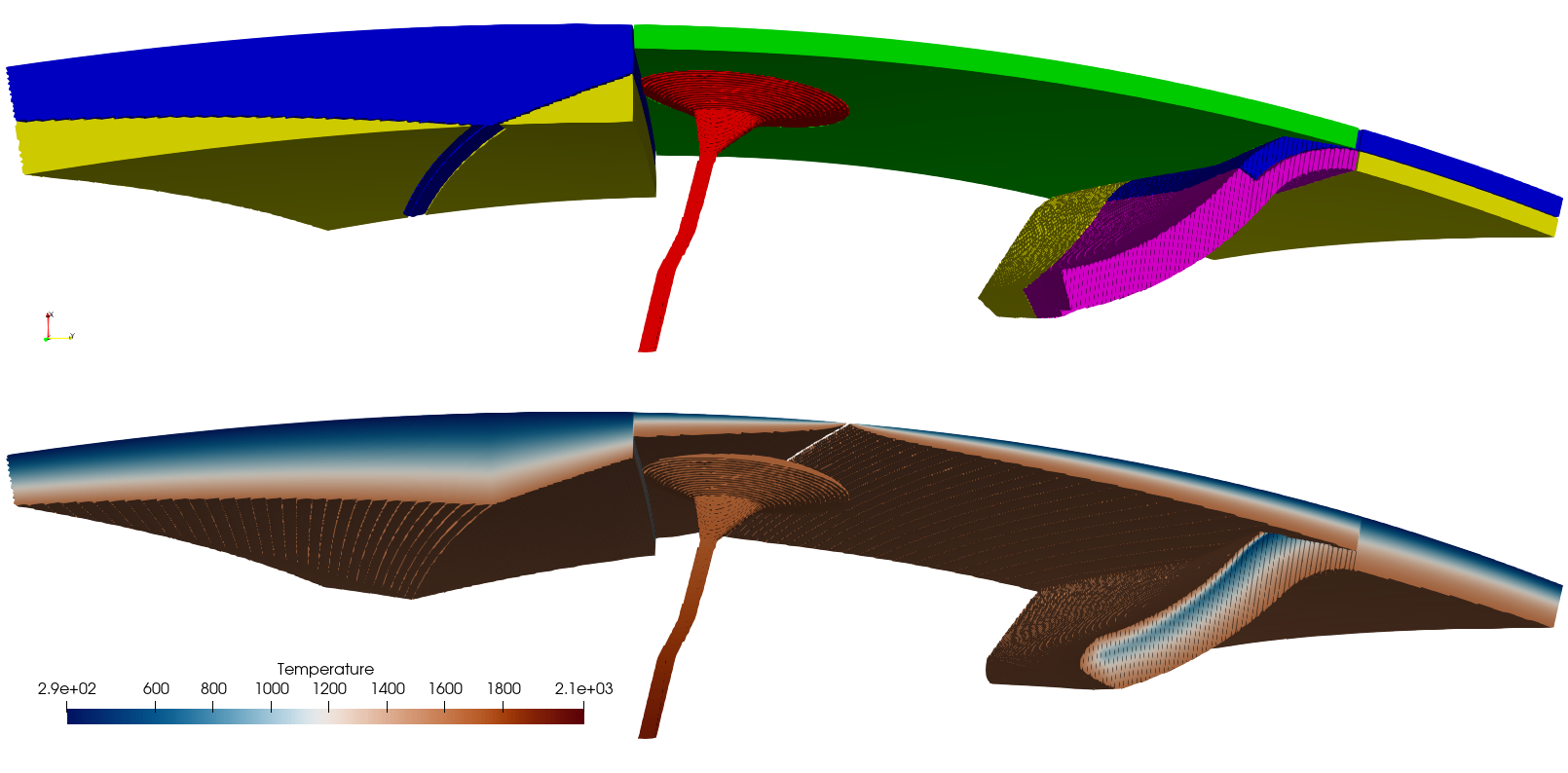
Basic Starter Tutorial section 19 high resolution result. This has 8 times the resolution than the grid file above. Note that you can see the Earth’s curvature!#